Mt. Reynolds — SW Talus/Ridge
⬇ GPX / track⚠ unverified🚐 Join the caravan
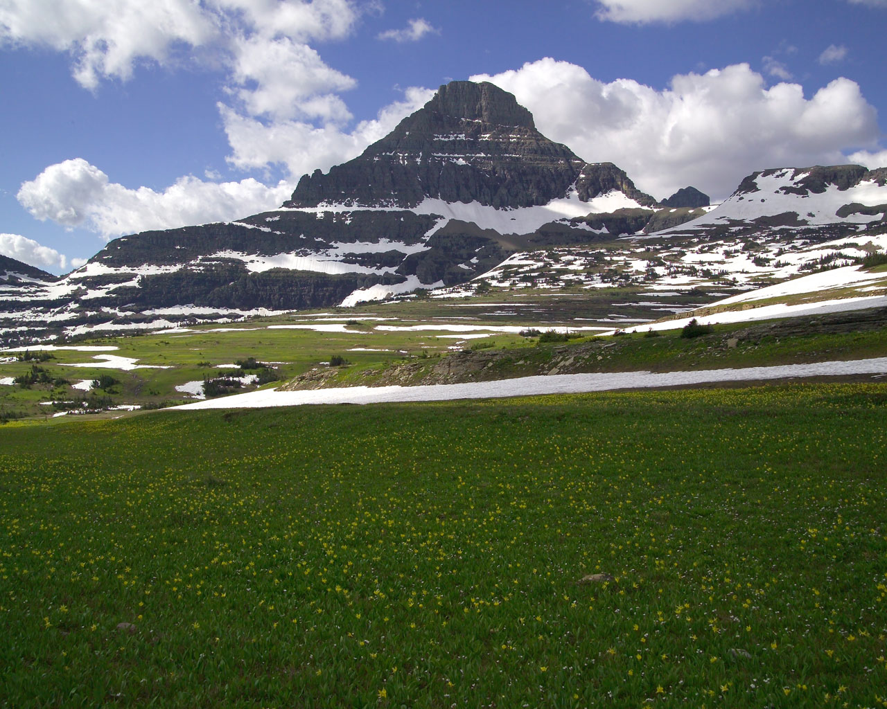
Reynolds Mountain (9,125'), 1.5mi south of Logan Pass — a striking slab on the Going-to-the-Sun Road. The standard SW talus route is a class 2-3 scramble; the airy ridge lines add exposed low-5th on Glacier's notoriously loose sedimentary rock. Approach via the Hidden Lake Trail from Logan Pass.
🚗 Getting there & comms
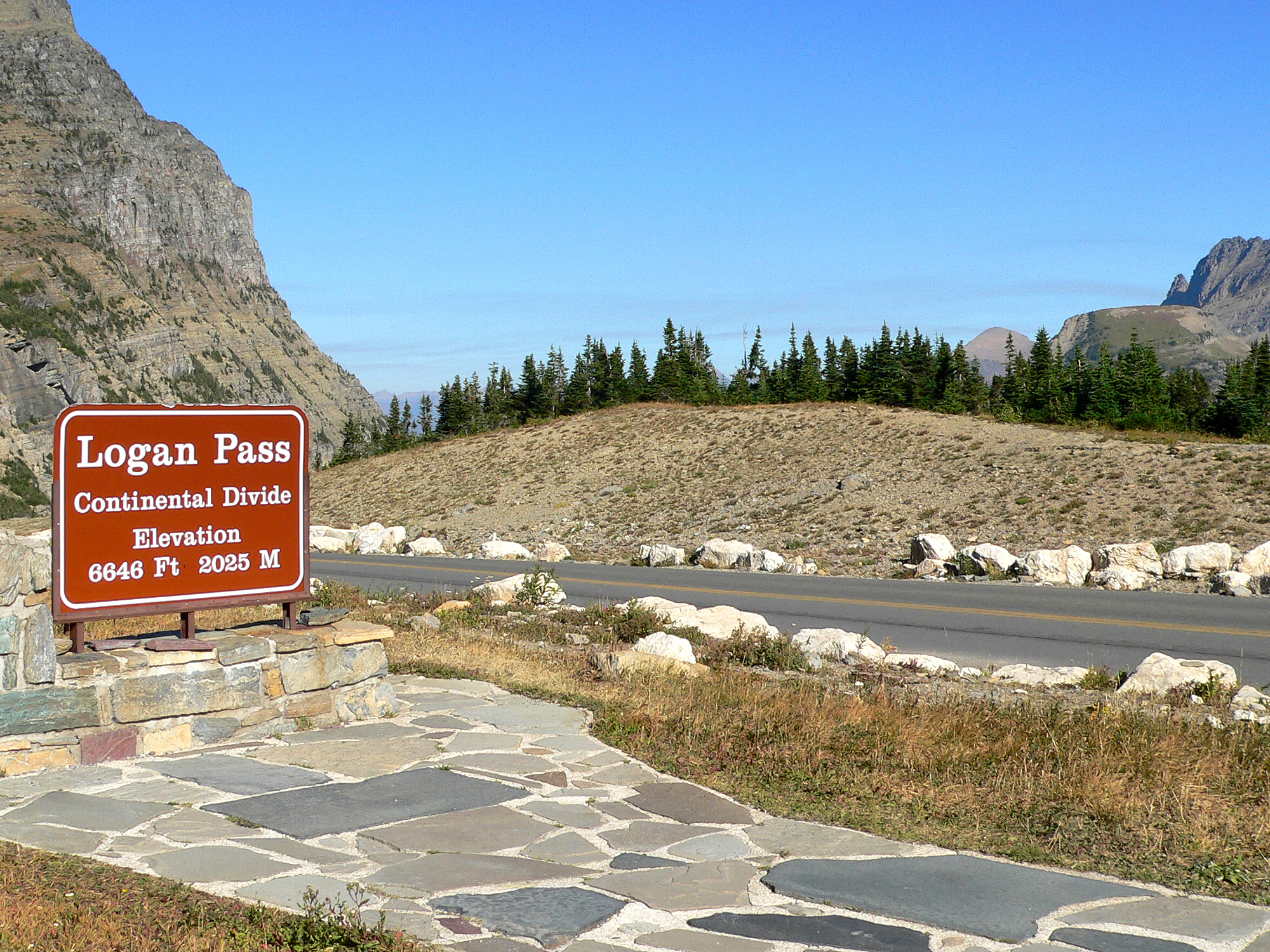
Trailhead: Logan Pass (Hidden Lake trail)
Logan Pass on Going-to-the-Sun Rd. Vehicle reservation required in summer; lot fills by dawn.
🗺️ Google Maps directions⛽ Last services: West Glacier, MT (~32 mi west of Logan Pass via GTSR): gas, small grocery/deli, lodging. Whitefish, MT (~25 mi northwest of West Glacier): full services, grocery, restaurants. St. Mary, MT (~18 mi east of Logan Pass): limited gas and services. Cell signal (AT&T and Verizon) in West Glacier and Whitefish is solid; both carriers fade significantly on GTSR heading toward Logan Pass. Last reliable signal: West Glacier (west approach) or St. Mary (east approach). No signal at Logan Pass.
📶 Cell signal: AT&T and Verizon both solid in Whitefish and West Glacier. Signal degrades substantially on Going-to-the-Sun Road approaching Logan Pass and is absent at the pass and on the Reynolds Mountain objective. Last reliable cell: West Glacier (west) or St. Mary (east). Satellite communicator essential for the route.
🧗 Routes
🎒 Gear & food
Rack: Mostly a scramble. For the airy ridge: a couple of slings + small cams for belays/short-roping. HELMET essential (choss).
Ropes: A short 30-40m rope for the exposed ridge sections (optional on the talus route).
Footwear: Sturdy trail runners/approach shoes + helmet; microspikes early/late season for snow on the approach.
🪓 Mountaineering: Helmet ESSENTIAL (loose choss); ice axe + microspikes/crampons for snowfields into July; headlamp.
🍫 Food: Full day from the pass — ~2,500-3,000 kcal + extra water.
🩹 Med/repair kit: Gauze pads + medical tape · Athletic tape (ankle support on talus/scree) · SAM splint (ankle/knee on steep descending terrain) · Ibuprofen 200 mg tabs (AMS headache, general) · Blister care (moleskin — boot-heavy scramble) · Electrolyte tabs/salt caps · Sunscreen SPF 50+ + SPF lip balm (high UV + snow reflection) · Glacier/high-UV sunglasses · Emergency space blanket (summit temps can drop fast) · Nitrile gloves x2 · Headlamp (early start, weather delays) · Water filter or treatment tabs (snowmelt streams on approach) · Hand warmers x2 (summit cold + wind) · Ace bandage / compression wrap
🪢 Skills needed
- Exposed alpine scrambling
- Loose-rock (Glacier choss) travel
- Short-roping/simul on the ridge
- Route-finding + weather timing
⏰ Start & altitude
🌄 Timing: Late July: sunrise ~5:40 AM, sunset ~9:00 PM (MDT, lat 48.7°N, approx.). Alpine scramble/climb — leave Logan Pass Visitor Center parking by 5:30–6:00 AM to summit by 9–10 AM and be off the exposed ridge well before noon. Glacier NP gets violent afternoon lightning storms; summit goal is 10:00–10:30 AM absolute latest. Afternoon thunderstorms build over the divide by 12–1 PM most summer days.
🫁 Altitude & sun: Logan Pass Trailhead: ~6,646 ft. Mt. Reynolds summit: 9,125 ft. Elevation gain: ~2,479 ft. Coming from Austin (~489 ft), you gain over 6,000 ft in one day's drive; AMS is a real risk. Plan a night in the Flathead Valley (~3,000 ft) or West Glacier area before going to Logan Pass. At 9,125 ft: expect shortness of breath on sustained scrambling, possible headache — descend if it worsens. UV is intense on the exposed ridge and snowfields; SPF 50+ on all skin, SPF lip balm, and high-quality UV-rated sunglasses or glacier glasses (snow reflection). Wind and cold are significant — bring layers even in July (summit temps can drop below 40°F with wind).
✅ Before you leave the trailhead
Auto-built from this dossier — ticks save on this device.
🏕️ Land · camp · water · permits
🪧 Land & passes: National Park Service — Glacier National Park. Entrance fee or America the Beautiful Interagency Annual Pass required. Vehicle reservation for Going-to-the-Sun Road / Logan Pass required in summer (recreation.gov timed entry). Backcountry camping requires a separate NPS backcountry permit.
🔥 Campfires: No campfires — alpine zone, stove only. Glacier National Park prohibits campfires in all backcountry zones; designated front-country campgrounds may have fire rings but alpine bivies above treeline are stove-only. Swiftsure Ridge is above treeline — canister stove required.
🆓 Free camping nearby:
- No camping at Logan Pass — day-use only
- Nearest free dispersed: Flathead National Forest immediately west/south of the park boundary — Forest Road 569 (Skyland Road) ~9 mi from Hwy 2, multiple pull-off sites; McGinnis Creek dispersed sites ~10 min from West Glacier
- Ryan Road dispersed camping ~10 min from West Glacier — ~10 primitive sites on a navigable dirt road
- No dispersed camping inside Glacier NP boundaries — all backcountry camping requires a permit
Camp:
- Day-trip from Logan Pass (no camping at the pass). Backcountry permit if camping elsewhere.
💧 Water: Bring water; none reliable on route (Hidden Lake area below)
📋 Permits: Glacier NP entrance + VEHICLE RESERVATION for Going-to-the-Sun Road / Logan Pass in summer (timed entry). Backcountry permit only if camping.
🚽 Toilet: Logan Pass Visitor Center; WAG bag on route.
⚠️ Hazards · fire · emergency
- GRIZZLY country — Logan Pass is prime habitat, carry spray
- Extremely loose rock — helmet
- Afternoon lightning on the exposed ridge
- Snow on approach into July, big exposure
Grizzly + black bears (spray required), mountain goats, marmots; busy with hikers near the pass.
🔥 Fire & smoke: Glacier NP has active wildfire history — the Reynolds Creek Fire has burned in the Reynolds Mountain area in the past. Smoke from fires across western Montana, Idaho, and Canada routinely blankets the park July–September, sometimes significantly degrading air quality and visibility. GTSR may close sections during active fire events. Check nps.gov/glac current conditions and InciWeb Montana before travel.
🪂 Bail / retreat: Swiftsure Ridge route is mostly a steep hike/scramble (class 3, short class 4 sections). Bail options exist throughout — the ridge can be descended back the way you came at any point before the final headwall. Standard descent is the SW Talus Slope (class 2-3) to the Hidden Lake trail and back to Logan Pass — no ropes required, ~3 miles total descent. If caught by weather: get off the ridge immediately to the talus bowl below, move into trees if possible. No technical rappels required for normal descent; it's a walk-off. The trailhead and parking at Logan Pass are only 1–2 miles from the summit.
🆘 Emergency contacts
- Emergency — Dial 911
- Glacier National Park (main) (406) 888-7800 — For emergencies dial 911; park rangers respond via 911 dispatch
- Flathead County Sheriff (non-emergency) (406) 758-5610 — 920 S. Main St Suite 100, Kalispell, MT — Logan Pass is in Flathead County
- Two Bear Air Rescue — Helicopter SAR operating in NW Montana and Glacier NP — dispatched through 911
- Kalispell Regional Medical Center (nearest Level II Trauma) (406) 752-5111 — 310 Sunnyview Lane, Kalispell, MT 59901 — 24hr emergency; ~1 hr from Logan Pass
🌤️ Live conditions
Auto-updated 12h ago · °F · tap a link for the mountain-specific picture ↓
🦟 Mosquitoes July; season late-July to Sept (snow-free). GTSR fully opens ~early-mid July.
👀 In the field
Tap any for ID, edibility & first-aid.
🏛️ Access · ranger · pass
Visitor center: Logan Pass Visitor Center — on Going-to-the-Sun Road at 6,646 ft; open mid-June to mid-September. General park line: (406) 888-7800.
Ranger station: St. Mary Visitor Center (east side) — (406) 888-7800; open daily in summer. Apgar Visitor Center (west side) also (406) 888-7800.
Pass: America the Beautiful pass or Glacier NP entry ($35/vehicle or $20/person, valid 7 days). Vehicle reservations required for Going-to-the-Sun Road May 26–Sep 8 (6 am–3 pm entry window) — book at Recreation.gov or ride the free park shuttle.
Official page ↗🎣 Fishing
No license required to fish inside Glacier NP boundaries (park entrance pass serves as fishing permit). Species: west slope cutthroat trout (native, catch-and-release only), rainbow trout, lake trout, grayling, and bull trout (threatened — strict C&R). Artificial lures/single-hook only throughout the park. Hidden Lake (below the overlook) is accessible with a longer hike and holds cutthroat. Flathead River tributaries just outside the park require a Montana fishing license.
🔭 Points of interest
Fire lookouts, old mines, wreckage, historic relics nearby.
- Hidden Lake Overlook — 1.4-mi hike from Logan Pass Visitor Center to stunning overlook above Hidden Lake; viewpoint of Sperry Glacier with binoculars. Glacier lilies and mountain goats regularly visible.
- Going-to-the-Sun Road (historic civil engineering landmark) — Completed 1932 — designated a National Historic Civil Engineering Landmark. The drive itself is a cultural and scenic landmark.
- Sperry Glacier — Visible with binoculars from Hidden Lake Overlook — one of the named glaciers in the park, shrinking rapidly. Accessible by longer backcountry route.
- Logan Pass Visitor Center — Interpretive exhibits on alpine ecology. Excellent ranger programs. The staging point for all Logan Pass objectives.
- St. Mary Lake / Sun Point — 18 mi east of Logan Pass — one of the most photographed lakes in the park with dramatic peaks and glacier views.
📍 Nearby & other interest
- Hidden Lake Overlook
- Dragons Tail
- Clements Mountain
- the Logan Pass Seven-Summits scramble
💬 Comments
Comments are reviewed before they show up.